
BRIEF DESCRIPTION:
Pérdida de vegetación y vegetación secundaria (formaciones boscosas y no boscosas).
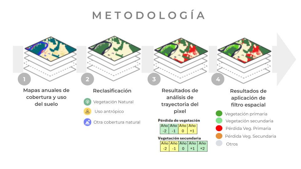
Para generar estos productos se utilizó de insumo los mapas anuales de cobertura y uso del suelo (LULC) de la Colección 3.
Se tomó como año de inicio 1999, ya que años antes los mapas presentan inconsistencias temporales debido a la escasez de imágenes satelitales disponibles que generaron vacíos de información.
A partir del año 1999 se comenzó a aplicar el conjunto de reglas del algoritmo para identificar eventos de pérdida de vegetación y vegetación secundaria, detectados desde el año 2001. Esto se realizó analizando los cambios anuales de cada píxel en los mapas, considerando tanto los años anteriores como los posteriores a cada año evaluado, según los criterios definidos para el algoritmo.
Consecutivamente a la aplicación de las reglas (Tabla 1) se aplicó un filtro espacial de 0.5 hectáreas:
| Loss t = | VN t-2 |
| VN t-1 | |
| A t | |
| A t+1 | |
| Secondary vegetation t = | A t-2 |
| A t-1 | |
| VN t | |
| VN t+1 | |
| VN t+2 |
VN = Vegetación Natural [ Formaciones boscosas (Bosque, Bosque seco, Manglar, Bosque inundable) y Formaciones naturales no boscosas (Zona pantanosa o pastizal inundable, Pastizal / herbazal, Matorral, Loma costera y otras formaciones no boscosas ]
A = Uso Antrópico [ Pasto, Mosaico agropecuario, Agricultura (Palma aceitera, Arroz, Otros cultivos), Infraestructura urbana, Minería, Plantación forestal y Acuicultura ]
t = 1999,…, 2024.
Based on the trajectory analysis along the time series, the algorithm assigns each pixel to one of the established classes for the product:
| Class | Description | Value |
| Anthropogenic | Pixel classified as anthropogenic that did not undergo changes until the year analyzed. | 1 |
| Primary Veg. | Indicates absence of vegetation loss, meaning natural vegetation that remains from the beginning of the series until the year of analysis. | 2 |
| Secondary Veg. | Areas with a history of anthropogenic use followed by a change to natural vegetation before the year of analysis. | 3 |
| Primary Veg. Loss | Areas that transition from Primary Vegetation to Anthropogenic in the year of analysis. | 4 |
| Recovery for Secondary Veg. | Areas with a history of Anthropogenic use followed by a change to natural vegetation specifically in the year of analysis. | 5 |
| Secondary Veg. Loss | Areas that change from Secondary Vegetation to Anthropogenic in the year of analysis. | 6 |
Para obtener más detalles sobre la metodología del módulo de pérdida de vegetación y vegetación secundaria, acceda a este apéndice de ATBD.